

Traditional as-built documentation often relies on manual measurements, which can be time-consuming and prone to errors. 3D scanning brings unmatched accuracy and efficiency to the process, delivering detailed digital models of your space that can be viewed, shared, and utilized instantly.
Capture your space in 3D
Capture your space in 3D

About
PAIME is specialized provider of 3D scanning and as-built documentation services, dedicated to delivering accuracy, efficiency, and clarity for every project. By transforming real spaces into detailed digital models, we empower architects, engineers, contractors, property owners, and managers to make informed decisions with confidence.
Our mission is simple: eliminate guesswork, reduce costly errors, and save time. With our precise 3D documentation, you gain reliable data that supports planning, design, construction, and long-term property management. Whether you’re developing, renovating, showcasing, or maintaining a space, we provide the tools you need to move forward with certainty.
What is a 3D Scan?
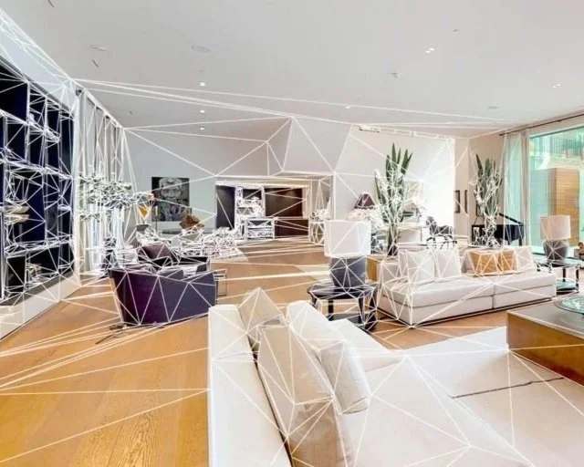
A 3D scan is a highly accurate digital capture of a physical space. Using advanced scanning technology, millions of data points are recorded to create a detailed three-dimensional model of a building, room, or structure.
Unlike traditional measuring methods, which rely on manual tools and can miss key details, a 3D scan provides a complete, precise digital “twin” of the space. This digital model allows users to:
Visualize the property from every angle in an interactive format.
Measure dimensions with millimeter-level accuracy.
Document existing conditions for renovations, construction, or future planning.
Share the space virtually with teams, clients, or stakeholders anywhere in the world.
In short, a 3D scan is the foundation for accurate as-built documentation — giving you confidence that every detail has been captured and preserved.
What are As-Built Documentations?
As-built documentation refers to a precise set of drawings or digital models that represent a building or space exactly as it exists — not just how it was originally designed.
During construction or after years of use, buildings often differ from their original plans due to renovations, field adjustments, or upgrades. As-built documentation captures these real-world conditions accurately, ensuring you have up-to-date records of your property.
Why they matter:
Provide an accurate baseline for future renovations or expansions.
Help contractors and engineers avoid costly errors by working from reliable data.
Support facility management with clear information on layouts, systems, and dimensions.
Serve as valuable records for property sales, leasing, or insurance purposes.
In short:
As-built documentation is the “true blueprint” of your property — a reliable record you can trust for years to come.
Our Basic Services
3D Scan
Interior 3D Scan
Our Interior 3D Scanning service captures the full layout and details of any indoor environment—such as commercial units, residential properties, or office spaces—using advanced 3D imaging technology. The result is a precise, interactive digital model that documents every wall, fixture, and finish with measurable accuracy. Ideal for architects, contractors, and property managers, this scan provides reliable as-built data, simplifies renovation planning, and offers clients a realistic virtual walkthrough of the interior space.
Exterior 3D Scan
Our Exterior 3D Scanning service captures the full geometry and visual details of building exteriors, facades, and surrounding site areas with high-resolution precision. Using the latest technology for outdoor scanning, we create accurate digital twins that reflect real-world dimensions and textures, even under challenging lighting conditions. This service is ideal for documenting building conditions, supporting architectural design, construction verification, and property assessments—delivering a comprehensive, measurable view of your exterior environment.
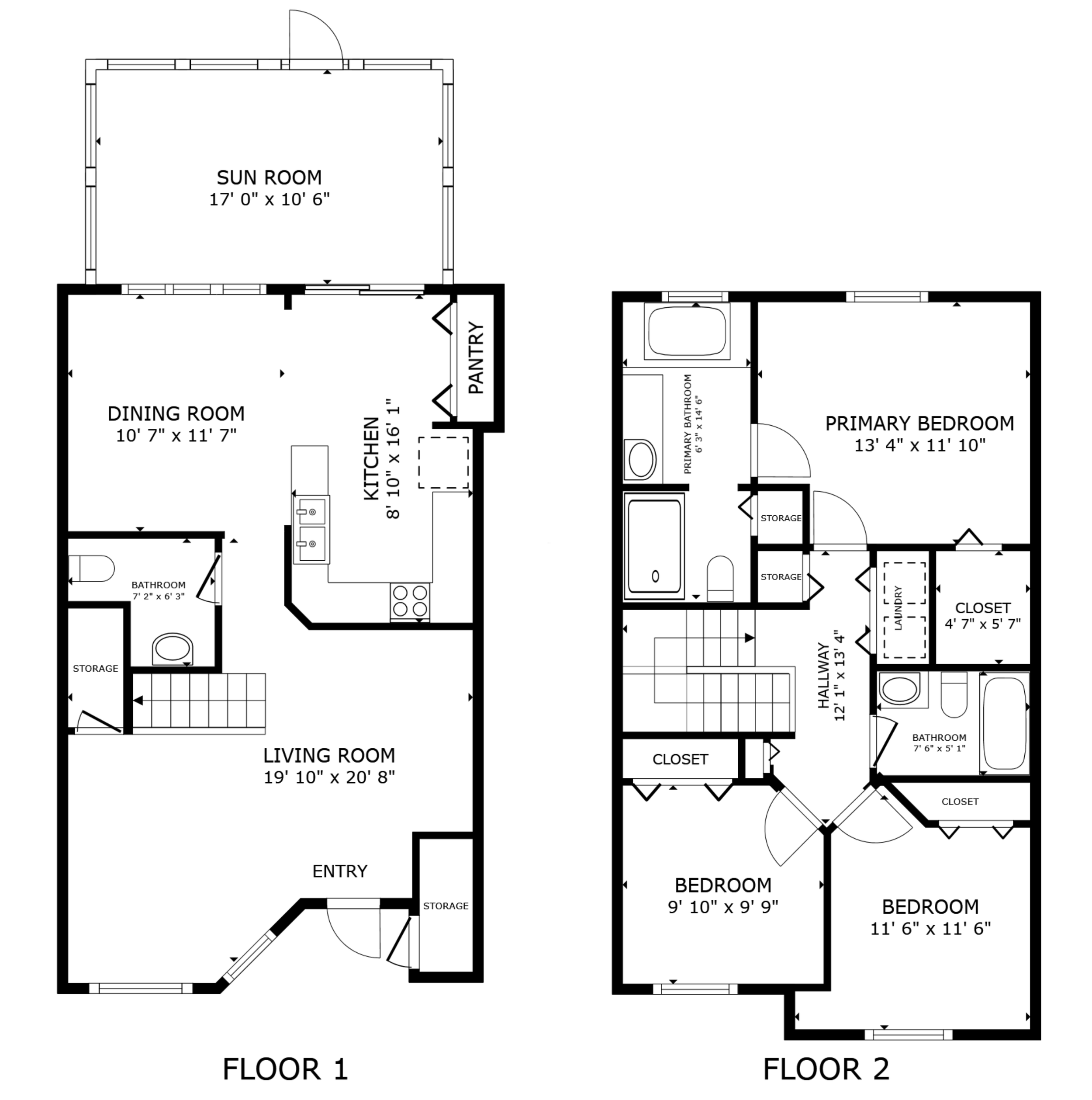
2D Schematic Floor Plan
Our 2D Schematic Floor Plan service converts your 3D scans into professional, ready-to-use floor plans that accurately reflect the layout and dimensions of any space. There’s no need for manual measuring—our process leverages the data captured during the scan to produce detailed diagrams that clearly show walls, doors, and room configurations. Floor plans are delivered in multiple formats, including PDF, PNG, and SVG, making them easy to share, edit, or incorporate into marketing materials.
Ideal for real estate professionals, architects, and property managers, these schematic floor plans help clients and stakeholders visualize spaces quickly and effectively. By providing precise, visually clear layouts, they streamline planning, marketing, and renovation processes. For this service, we provide the 3D scan first, and then convert it into precise, visually clear floor plans—delivering fast, accurate, and professional results that save time and enhance the presentation of your property.
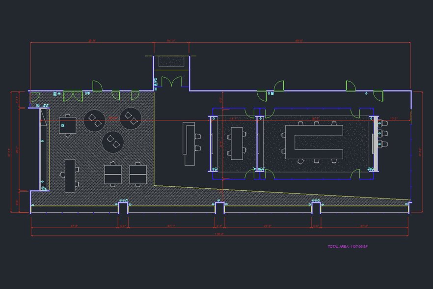
CAD Drawing Services
Computer-Aided Design (CAD) drawings are precise 2D digital representations of physical spaces, created to document and communicate architectural layouts, construction details, and interior configurations. They serve as an essential foundation for renovation, design, and facility management projects, enabling professionals to work from accurate as-built information instead of outdated or manual measurements.
Our CAD Drawing service transforms spatial data from your 3D scans into detailed .DWG files, compatible with AutoCAD and other design software. Depending on your project requirements, the drawings can include:
Architectural Features:
Walls, doors, floors, ceilings, stairs, roofs, and bathroom fixtures.
Interior Furniture:
Desks, tables, cabinets, shelves, chairs, appliances, and kitchen elements.
Electrical Elements:
Power and data outlets, lighting fixtures, switches, alarms, and related components.
These CAD files are ideal for spaces up to 125,000 ft² (11,610 m²) and are delivered ready for editing, coordination, and integration into your workflow. For projects requiring advanced system modeling such as mechanical, electrical, or plumbing design, we recommend our BIM Services for a more comprehensive 3D solution.
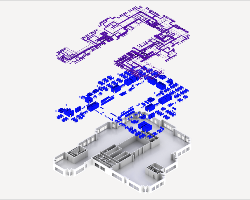
BIM Services
Building Information Modeling (BIM) is a digital representation of a physical space that integrates geometry, data, and structure into one intelligent model. It allows architects, engineers, and contractors to visualize, coordinate, and manage every aspect of a building project more efficiently—from design through construction and operation.
Our BIM service transforms high-quality 3D scans into detailed, ready-to-use BIM deliverables compatible with Autodesk® Revit and other design platforms. The package includes a complete .RVT model, 2D floor and reflected ceiling plans (.DWG), IFC (Industry Foundation Classes) files, and a point cloud (.RCS) for precise reference. This service is ideal for professionals in architecture, engineering, and construction (AEC) who require accurate as-built data for design development, renovation planning, or facility management. We deliver reliable, structured models that streamline collaboration and decision-making across commercial, retail, and institutional projects.
Included in the Revit Model:
The BIM model includes all visible interior elements from the point cloud, modeled at LOD 200 (walls, floors, doors, ceilings, and fixtures), with wall studs simplified as generic walls. Exteriors are generally excluded, though visible features like pathways, railings, stairs, and pools can be included; plants, vehicles, and exterior building surfaces are not modeled. Roof geometry is modeled at LOD 200 when visible in the scan.
Format Options:
Architecture (Standard)
Architecture + Interior Furniture
Architecture + MEP
Architecture + MEP + Interior Furniture
Architecture + Complex Industrial MEP —recommended for specialized spaces such as mechanical rooms, electrical rooms, fulfillment centers, manufacturing facilities, warehouses with heavy machinery, and data centers.
Other Services
Point Cloud Data Package
Use for: Architects, engineers, and design professionals who need raw 3D data for modeling.
Provides high-resolution 3D point cloud files and assets that can be imported into CAD or 3D software for detailed measurements, modeling, and design documentation.
E57 Point Cloud File
Use for: Professionals requiring a universal point cloud format.
Exports the 3D scan data in industry-standard E57 format, compatible with software like ReCap, Revit, or AutoCAD for precise spatial analysis and modeling.
Real Estate Marketing Distribution
Use for: Realtors, brokers, and property managers.
Facilitates direct integration of your 3D tours into real estate platforms and listings, helping properties gain more visibility and engagement online.
TruePlan™ for Xactimate®
Use for: Insurance and restoration professionals.
Converts 3D scans into ready-to-use floor plan files (.SKX) compatible with Xactimate®, streamlining estimating and claims documentation.
360° Publishing for Vacation Rentals
Use for: Vacation rental owners and property managers.
Publishes 3D tours directly on vacation-rental platforms like Vrbo, giving potential guests an immersive viewing experience before booking.
Sketch File Export
Use for: Designers and estimators who prefer 2D workflows.
Delivers detailed floor plan sketches in .SKX format for import into compatible design or estimating software, providing accurate as-built data.
Note: Pricing varies based on project size, type, and specific requirements. Each property is unique, and final costs are determined after reviewing the scope of work.
Who benefits from 3D scanning?
-

Property Owners
Maintain precise records for renovations, insurance, or resale.
-

Architects
Start projects with accurate as-buil and eliminate guesswork.
-

Contractors
Streamline planning, reduce costly rework, and verify existing conditions.
-

Engineers
Access reliable spatial data for system coordination.
-

Real Estate Agents
Market properties with immersive 3D tours and interactive floor plans.
-

Facility Managers
Keep up-to-date documentation for operations, safety, and compliance.
-

Interior Designers
Visualize existing conditions with precision before starting design concepts.
-

Short-Term Rental Hosts
Showcase listings with immersive tours and professional floor plans.
-

Event Planners & Venues
Plan layouts, seating, and logistics accurately.
-

Hospitality & Retail
Hotels, resorts, and stores can document spaces for renovations, marketing, and brand consistency.
-

Insurance Companies
Pre-loss documentation and claims verification.
-

Legal Professionals
Accurate site conditions for evidence.
Follow us on social media
Get a Quote
Interested in our services? Fill out the form below and we will be in touch shortly. We can’t wait to hear from you!